1. Gulmarg – Jammu and Kashmir:
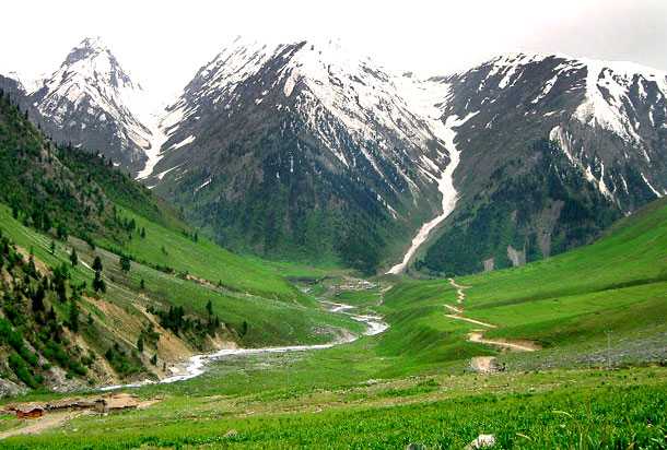
Also known as “Gaurimarg”, Gulmarg is a treat for the eye for people craving for snow plus it is a popular skiing destination. It is 56 Kms from Srinagar in Baramula district. With temperatures dropping to as low as -7°Celsius in January, tourists need to come prepared for the weather extremes. This town with a small population of under two thousand was rated by CNN as the 7th best ski destination in Asia. While the scenery is enough to keep you smitten, there are a few attractions like the Maharani Temple, St. Mary’s Church and Gulmarg Gandola – a ropeway that ferries about 600 people per hour between Gulmarg and Apharwat Peak (4,200 mts altitude). And if you are a sucker for music, films and photography, you need to come and join the annual three day Gulmarg Winter Festival held in March every year.
Bonus – Do check out the almost secret Alpather lake, 13 Kms from Gulmarg. It is also known as the ‘Frozen Lake’ since it is actually frozen for near seven months from November to May. Tourists go for the one day trek to the Alpather lake throughout the year, though considering the extreme weather condition and high altitudes, it is recommended to plan for the trek diligently.
2. Srinagar – Jammu and Kashmir:
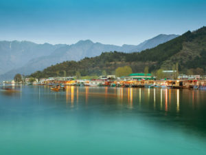
The summer capital of the Jammu and Kashmir, Srinagar is the heart of this paradise on earth – Kashmir. The city boasts of four lakes with Dal lake being the most popular tourist destination sporting the famous houseboats and shikaras . And then there are the five Mughal gardens which have a majestic presence about them. There are ancient shrines, temples, mosques and churches to visit for those who want to pay obeisance to God while assimilating the mesmerizing beauty of the valley. Some of them are the ancient Shankaracharya mandir, Zeastha Devi mandir, Hazratbal shrine, Jama Masjid, Gurdwara Chatti Patshahi and Holy Family Catholic Church. And then there is the Hari Parbat fort supposed to have been built in the 6th century and subsequently fortified by the mughals and later rulers. Official permission is required to visit the fort by submitting an application.
The climate can get very cold in the winters with average low temperature of -2°C and can sometimes go below -5°C due to cold waves. Handicrafts and dry fruits are high on the shopping list and good markets to buy stuff are Lal Chowk Ghantaghar and the Wholesale market and the former is supposedly cheaper. Some other popular things to do are shikara ride or houseboat stay on Dal Lake or Nageen Lake, paragliding and trekking. And yes, Srinagar is a perfect place to start for a hill-station tour of Gulmarg, Pehalgam and Sonamarg.
3. Pahalgam – Jammu and Kashmir:
Located in the Anantnag district, Pahalgam is a beautiful hill station that is popular for its natural beauty. With temperature touching subzero and this area receiving heavy snowfall during winter it is a perfect holiday destination particularly during winters.
Also read: 10 LESSER KNOWN HILL STATIONS IN INDIA
4. Patnitop – Jammu and Kashmir:
A beautiful hill station located in the Udhampur district in Jammu and Kashmir offers magnificent snow peak views and also provides the perfect landscape for adventure sports such as skiing and zorbing.
5. Shimla – Himachal Pradesh:
Located in Himachal Pradesh Shimla, is a beautiful city that is bounded by Mandi and Kullu in the north and Kinnaur. During winters it receives heavy snowfall and as a result provides an ideal landscape for winter sports like skating and snowing.
6. Kufri – Himachal Pradesh:
Located at about 13 km from Shimla Kufri, is beautiful hill station that is popular as a skiing destination during winters. It also provides for some magnificent views of its surroundings.
Also read: A FEW UPCOMING HILL STATIONS IN INDIA
7. Dharamshala – Himachal Pradesh:
In the Kangra Valley, there is a scenic city called “Dharamshala”. This city is a home to the Dalai Lama. This city receives heavy snowfall and is known for its scenic beauty during the winter season. The snowfall recorded on January 7, 2012 was the heaviest recorded in recent times.
8. Auli – Uttarakhand:
Auli a beautiful hill station in Uttarakhand is an important skiing destination located in the Himalayan mountain ranges. Other adventure sports such as mountain climbing, snowboarding etc are also popular. This hill station also provides for magnificent views of the snow clad mountain peaks of the Himalayas.
9. Mussorie – Uttarakhand:
Popularly known as the “Queen of the Hills” Mussorie, is a beautiful hill station located in the Dehradun district in Uttarakhand. This hill station experiences heavy snowfall with the temperature dropping below zero degrees. It also provides for magnificent views of the Doon valley and Shiwalik ranges especially during winters.
Also Read: EERIE: WHAT CONNECTS MUSSOORIE TO GHOST STORIES?
10. Chopta – Uttarakhand:
Known as “Mini Switzerland” Chopta, is a beautiful hill station located in Uttarakhand. During winters this scenic hill station provides for magnificent views of the snow clad Himalayan ranges such as Trishul, Nanda Devi, and Chaukhamba.
]]>
 Situated in the Pauri Garhwall district, it is renowned for its beautiful landscape which comprises of beautiful Deodar and Oak trees as well as magnificent Apple orchards.
Furthermore, this hill station is also popular for the majestic panoramic views that it provides for. In addition, although this amazing spot has been less explored in recent years it is slowly but surely becoming a popular tourist destination.
Read More: WHY AULI IS A MUST VISIT DESTINATION?
a. How to reach Khirsu?
[put_wpgm id=2]
Khirsu Map
By Train:
The nearest railway station to this hill station is at Rishikesh located at a distance of 132 kms. The Rishikesh Railway Station is well connected to major railway stations in India. In addition, bus and car services are available to Khirsu from this station.
By Road:
The ideal starting points to reach Khirsu would be via Rishikesh, Rudraprayag, Devprayag, Dehradun, and Srinagar.
a. Via Rishikesh:
There are two routes available from Rishikesh, via NH-7 which takes 4 hours and 13 minutes and via NH-7 and Devprayag Pauri Road which takes about 4 hours and 16 minutes.
b. Via Rudraprayag:
There are two routes available from Rudraprayag, via Khankra Khedakhal Road which takes about 1 hour 50 minutes and via NH-7 which takes 2 hours 23 minutes.
c. Via Devprayag:
There is one route available from Devprayag, via NH-7 which takes 1 hour and 53 minutes.
d. Via Dehradun:
There are two routes available from Dehradun, via NH-7 which takes 5 hours and 13 minutes and via NH-534 which takes 6 hours 49 minutes.
e. Via Srinagar:
There are three routes available from Srinagar, via NH 44 and NH 7 which takes 22 hours and 38 minutes, via NH 44 which takes 22 hours and 40 minutes, and via NH-44 and Meerut-Pauri National Highway which takes 23 hours and 33 minutes.
By Air:
The nearest airport is located in Dehradun. The Jolly Grant Airport is located at a distance of 145 kms. This airport is well connected to the major cities in the country. Taxi services are available from this airport to Khirsu.
Climate and the best time to Khirsu:
The climate in Khirsu can range from being hot in summers to being cold during winters with, the temperatures during the summer from March to May ranging from 40 degrees to 15 degrees. The rainfall received during monsoons beginning from June and extending to Khirsu is heavy. While the temperature during winter months that begins in October and ends in February drops to about 6 degrees minimum. The best time to visit this picturesque hill station is from September to April.
Places To Visit Around Khirsu :
There are few spots available in Khirsu which makes it a worth visit hill station. They are as follows:
- Apple Orchards: A number of beautiful orchards are found at this hill station which are truly worth visiting.
- Beautiful Landscape: The landscape surrounding this hill station is extremely beautiful and comprises of beautiful Deodar and Oak trees. It is this scenic beauty which makes Khirsu an ideal destination for activities such as walking and trekking.
Interesting Fact:
It is a Hindu shrine known as the “Ghandiyal Devi Temple” located at this beautiful hill station which attracts a large number of tourists. Furthermore, this temple is dedicated to Ghandiyal Devta also known as “Jai Shree Ghantakarna Swami”. In this shrine, a ritual of offering turmeric (also known as Haldi) is commonly offered by devotees. In addition, a festival known as the “Ghandiyal Mela” is celebrated annually at this temple on third Monday after the popular Hindu and Sikh festival Vaisakhi.
Also Read: TOP 10 HILL STATIONS IN THE HIMALAYAS
Image Credits: Wikimedia Commons
]]>
Read More: 5 REASONS WHY YOU SHOULD VISIT GULMARG
So let us now analyze the top 10 hill stations located in the Himalayas.
- Gulmarg: Is a beautiful hill station named in honour of Goddess Parvati and located in the Baramula district in Jammu and Kashmir. This hill station was renamed as Gulmarg which means meadow of flowers during the 16th century by Sultan Yusuf Shah of the Chak Dynasty. This scenic hill station is popular for its golf course and ski resort during winter. It is also popular for breathtaking views of the ridges and forests that eventually pave way to the snow clad slopes of the Khilanmarg and the Nanga Parbat peak. Major tourist attractions in this hill station include adventure sports like trekking and water rafting.
- Sonamarg: Is a beautiful hill station that is located in the Ganderbal district in Jammu and Kashmir. It is famous for providing a beautiful view of the countryside. It is also surrounded by beautiful mountains and pine forests and is located at about 84 km from Srinagar. It is famous for providing a perfect trekking track up to Thajiwas, a small valley located at the foot of the Sonamarg glacier.
- Srinagar: Is the largest city in Jammu and Kashmir and according to folklore means city of prosperity. This city is famous for its houseboat, canals, and Mughal Gardens. The popular Mughal Gardens are Shalimar and Nishat. Dal Lake is also a major tourist attraction in this city. Other popular tourist attractions in this city include Shankaracharya Hill, Hazaratbal Mosque, Hari Parbat Fort, etc.
- Ladakh: Is a region that is administered by Jammu and Kashmir and is commonly known for its extreme scenic beauty. It is located at an altitude of about 2500 to 4500 meters above sea level and is well known for its natural beauty. The landscape in Ladakh is also ideal for adventure activities and hence is famous for trekking, mountaineering, camping, water rafting. It is also known for its rich flora and fauna. Since the culture in Ladakh is closely linked to Tibet this region is also famous for wonderful Buddhist monasteries.
- Shimla: Is a beautiful hill station named after a Hindu goddess called Shyamala Devi, an incarnation of Kali and, is located in Himachal Pradesh. It is known for its all round natural beauty. It is also known for beautiful green pastures with snow clad mountain peaks in the background. Major tourist attractions in this quaint hill station include Mall, Christchurch, Narkanda etc.
- Kullu: Is a beautiful hill station located on the banks of the River Beas in the Kullu Valley. It is well known for its natural beauty. Some major tourist attractions include Kali Bari temple (dedicated to goddess Shayamala) and Raghunath temple which is dedicated to Lord Ram. This hill station is also known for shopping with Akhara Bazaar and Bhutti Weavers Colony being popular for it.
- Manali: Is an extremely scenic hill station that lies in the Kullu Valley at an altitude of 2,050 meters above sea level. This hill station is surrounded by magnificent mountains. It is also well known for its beautiful apple orchards. It is also an ideal spot for trekking.
- Dharamsala: Is a beautiful city/hill station located in the Kangra Valley in Himachal Pradesh. It is renowned for its picturesque beauty and as a result attracts a large number of tourists every year. It is surrounded by beautiful pine trees and deodar forest which only adds to its “old world charm”. A few major tourist attractions include colourful temples and Gompas.
- Nainital: Is a hill station located at Uttarakhand that was founded in 1841 by a sugar trader P Barron. It is surrounded by beautiful mountains on three sides. It is also known for magnificent landscapes.
- Darjeeling: Is a beautiful hill station located in West Bengal. It is renowned for its natural beauty. It is known for the spectacular view of the Kangchenjunga, the world’s third highest mountain peak. Additionally, it is also famous for the Darjeeling Himalayan Railway.
In conclusion, it would be safe to say that all the hill stations mentioned above are equally popular and, so which destination you should visit is eventually a matter of choice you have to make.
Also Read: 5 REASONS FOR VISITING KULLU
]]>Read More: SNOWFALL IN MARCH! PATNITOP
[put_wpgm id=64]
Srinagar Map
- Mughal Darbar:
Cuisine Type: Indian, Mughlai, and Kashmiri.
Cost for two: Rs 200 to Rs 350.
Hours of working: 09.30 am to 09.00 pm.
- Cafe De Linz:
Cuisine Type: Indian and Chinese.
Cost for two: Rs 300 to Rs 400.
Hours of working: 12.00 pm to 10.30 pm.
- Ahdoos:
Cuisine Type: Kashmiri.
Cost for two: Rs 280 to Rs 350.
Hours of working: 09.00 am to 11.00 pm.
- Coffea Arabica:
Cuisine Type: Bakery.
Cost for two: Rs 500 to Rs 700.
Hours of working: 09.00 am to 10.30 pm.
- Krishna Vaishno Dhaba:
Cuisine Type: Indian.
Cost for two: Rs 100 to Rs 150.
Hours of working: 08.00 am to 10.30 pm.
Also Read: 5 REASONS FOR VISITING PAHALGAM
]]>Read More: EERIE: WHAT CONNECTS MUSSOORIE TO GHOST STORIES?
How to reach Mussoorie?
[put_wpgm id=97]
Mussoorie Map
By train:
The closest railway station to Mussoorie is located in Dehradun. The Dehradun Railway Station in general is well con, in general, jor railway stations in the country with trains that includes Dehradun Shatabdi, Delhi S RohillaMussoorie Express operating from Delhi providing regular services to Dehradun.
By road:
Mussoorie is well connected to major cities in the state i.e. Uttarakhand via bus services. Direct bus services to Mussoorie are available from the following destinations in the state. They are
- Barkot- 89 kms.
- Dehradun- 35 km
- New Delhi- 290 km
- Hanuman Chatti- 129 km
- Nainital- 355 km
- Saharanpur – 110 km
- Srinagar Garhwal- 135 km
- Old Tehri- 76 km.
Dehradun and New Delhi are two starting points that lie in close proximity to Mussoorie.
a. How to reach Mussoorie from Dehradun: The shortest route to reach Mussoorie from Dehradun is via Mussoorie Rd as depicted in the map above. Alternatively, click on the Google Maps link here to view on Google Maps.
b. How to reach Mussoorie from New Delhi : There fastest route from New Delhi to Mussoorie is via Saharanpur Rd and the route map is depicted above. Alternatively, click on the Google Maps link here to view on Google Maps.
By air:
The nearest airport located to Mussoorie is in Dehradun. The Jolly Grant Airport in Dehradun is connected to most of the major cities via major airlines such as Jet Airways, SpiceJet, JetKonnect, Air India etc.
Climate and best time to visit Mussoorie Hills
Mussoorie in general experiences what can be termed as fairly “pleasant” summer which begins in March and ends in June with the maximum temperature hovering around the 37 degree Celsius mark. The rainfall received during the monsoons that begins in July and ends in September is generally “moderate” with landslides being a common phenomenon witnessed during this period and, hence travelling during this season is not advisable. The winter which begins in October and ends in February in general is “chilly” with the mercury dropping to below 0 degree at times. So with the winters being “chilly” and monsoons experiencing “landslides” the ideal time to visit this beautiful hill station is during the pleasant summer from March to June.
Places To Visit Around Mussoorie
Since Mussoorie is a picturesque as well as popular tourist destination in the country there are a few sites in this hill station that must be visited. A few of them are as follows
Municipal Garden:
Municipal Garden also known as Company Baghis essentially an attractive and colourful flower garden. This garden also comprises of an amusement park for children thereby making it an ideal family picnic spot and a must visit.
Gun Hill:
Gun Hill is considered to be the second highest peak in this scenic hill station, and is another popular tourist attraction. This spot offers a wonderful cable car that provides for a bird’s eye view of the entire region. From this point the magnificent views of a few Himalayan ranges that include Bunderpunch, Shrikanta, Pithwaraetc can also be witnessed thereby making it an ideal must visit.
Cloud’s End:
Cloud’s End is an extremely charming spot where you can truly experience the beauty of the thick Oak and Deodar forests. In addition, this spot also houses a beautiful heritage bungalow that oozes out dollops of colonial charm.
Camel’s Back Road:
The Camel’s Back Road is considered to be an absolute “jogger’s paradise” with a serene atmosphere and a clean green environment to go along with it.
Accommodation – Hotels, Resorts and Home Stays in and around Mussoorie:
Click on the link here to check out the places to stay near Mussoorie, Uttarakhand on Google Maps.
Also Read: WHAT CONNECTS RUSKIN BOND TO MUSSOORIE?
]]>Read More: WHY AULI IS A MUST VISIT DESTINATION?
How to reach Chopta?
[put_wpgm id=21]
Chopta Map
By train:
The closest railway station is located at Rishikesh which is well connected to some of the major railway stations in the country.
By road:
There are number of bus services available from New Delhi to Chopta. Taxi facility is also available from certain cities like Uttarkashi, Gopeshwar, Pauri, Srinagar, Gaurikund, Rishikesh, and Rudraprayag to Chopta.
By flight:
The closest domestic airport is Jolly Grant Airport of Dehradun. The nearest international airport is the New Delhi airport. With regular flights to New Delhi being available from most of the major cities in the country.
Climate and best time to visit Chopta
The climate of Chopta can best be described as “moderate” with the temperature during the summer months beginning from March and ending in May ranging from a maximum of 30 degrees and a minimum of 10 degrees. Winters months of November to February can be severe and can range from a maximum of 15 degrees to a minimum of -15 degrees. The monsoon season that begins in July and extends up to September is moderate and it is in this season that the scenic beauty of Chopta is enhanced. With summer being moderate the best season to visit Chopta begins in March and ends in May.
Places to Visit Around Chopta
Kalpeshwar Temple: This temple is devoted to Lord Shiva. It is a stone temple which can be accessed through a cave passage.
Tungnath Temple: It is located on the Tungnath Mountain Range. The arm of Lord Shiva is worshipped here. The entrance of the shrine has a stone figure of Nandi Bull, the mount of Lord Shiva.
KanchulaKorak Musk Deer Sanctuary: Located on the Chopta-Gopeshwar Road, this dense forest offers a panoramic view of nature. It is home to the musk deer.
Madhyamaheshwar Temple: This temple is dedicated to Lord Shiva and is located in Mansuna village. The stomach of Lord Shiva is worshipped here.
Chandrashila: This place offers an enigmatic view of the gigantic Himalayas. Chandrashila is the apex of the mountain on which Chopta and Tungnath Temple are situated. It is located at about 4000 meters above sea level.
Other places of interest include the Kalimath Temple devoted to Goddess Kali. The Kedarnath Temple is another wonderful site to visit. This temple is devoted to Lord Shiva. Gaurikund, named after Goddess Parvati, is a picturesque location that is nearly 50 kilometers from Chopta and has natural thermal springs.
Also Read: 9 EXTREMELY EXOTIC INDIAN HILL STATIONS
]]>Read More: 5 REASONS WHY YOU SHOULD VISIT GULMARG
How to reach Zanskar
[put_wpgm id=111]
Zanskar Map
- By train
The closest railway station to Zanskar is located in Jammu. The Jammu Railway Station is well connected to major cities in the country. There is a number of bus services available from this station to Zanskar that travels via Kargil.
- By road:
If you intend to drive down to Zanskar then the ideal way is to begin the journey from Srinagar using NH-1 and NH-301 route. This route includes Sonamarg, Baital, Dras, Kargil, and finally Zanskar.
- By air:
The nearest airport to Zanskar is located in Leh. The Leh Airport is well connected to major cities such as Jammu, Srinagar, and Delhi. An alternate option would be the Srinagar Airport also well connected to major cities in the country.
Climate and best time to visit Zanskar
The summers in Zanskar which begin in April and end in September are extremely pleased with the temperature ranging from a maximum of about 33 degree Celsius to a minimum of 4 degree Celsius. There is no particular monsoon season that exists in this region. While the winters are extremely “harsh” with the mercury dropping to a low of -10 degree Celsius and a high of -14 degree Celsius. So the ideal time to visit this place is from April to September during the pleasant summers.
Places To Visit Around Zanskar
There are a number of places in and around Zanskar worth visiting. They are as follows
- PhuktalGompa
The PhuktalGompa is a 14th-century Buddhist monastery located in this region. This monastery is renowned for mural fragments that are about 700-years-old. It is also surrounded by exquisite scenic beauty, and hence a major tourist attraction. In addition, it also possesses a guest house that comprises of four double rooms.
- KarshaGompa
The KarshaGompa is considered to be the largest Buddhist monastery in this region. It was apparently constructed during the 10th century. The prayer hall located inside this Gompa comprises of beautiful old murals and wooden columns. In addition, this monastery provides for picturesque views of the entire Karsha village located in close proximity.
- Penzella Pass
The Penzella Pass is an excellent vantage point located in this region that provides for magnificent views of the surrounding mountains and beautiful countryside. In addition, this pass also helps divide the Zanskar Valley to Suru Valley.
- Panikhar:
Panikhar is yet another important tourist spot located in this region. The famous fort called “Zorawar Singh” is located over here, and is a major tourist attraction.
Also Read: SNOWFALL IN MARCH! PATNITOP
]]>Read More: 5 REASONS WHY YOU SHOULD VISIT GULMARG
How to reach Suru Valley
[put_wpgm id=112]
Suru Valley Map
By train
The nearest railway station to the Suru Valley in Lehis located in Kalka. Furthermore, you can get bus and taxi services from Leh bus stand to Suru Valley.
By road:
If you intend to drive toSuru Valley then, there are two routes available i.e. via Srinagar and via Manali. They are as follows
Via Manali:
This route connects to NH-1 and includesKeylong, Kishtwar, Anantnag, Srinagar, Sonamarg, Baltal, Dras, Kargil, and finally Suru Valley.
Via Srinagar:
This route connects to NH-144A as well as NH-1 and includes Pathankot, Jammu, Rajouri, Shopian, Badgam, Sonamarg, Baital, and Kargil before eventually reaching Suru Valley.
By air:
The nearest airport is located in Leh. The Leh Airport is well connected to major cities in the country such as Delhi, Jammu, Srinagar, and Chandigarh. There are taxi or auto rickshaw services available from this airport to Suru Valley.
Climate and the best time to visit Suru Valley
The climate experienced in the Suru Valley during summers is which begins in April and ends in September are “pleasant” with the temperatures ranging from a maximum of 33 degree Celsius to a minimum of 4 degree Celsius. There is no monsoon season that exists in this region. The winters are extremely “severe” with temperatures ranging from -14 degree Celsius maximum to a minimum of – 10 degree Celsius, and which begins in November and ends in March. So the ideal time to visit this beautiful hill station is during summer i.e. in between April and September.
Places To Visit Around Suru Valley
There are a few must visit tourist attractions located in and around the Suru Valley. A few of them are as follows
- Sankoo
Surrounded by beautiful rocky mountains, this bowl shaped spot located in this valley is a must visit. It is scenically beautiful and includes lush green plantations and wild roses.
- Rangdum
Rangdum is an obliquely extended plateau that is surrounded by magnificent hills and beautiful mountains. This plateau is elevated at an altitude of 3657 meters above sea level. In addition, located in close proximity to this plateau is an 18th century Buddhist monastery popular with tourists, and is home to about 40 monks.
- KartseKhar
KartseKhar is an extremely old Buddhist village. It was established during the 7th century, and is renowned for possessing a 7 feet statue of Lord Buddha made up of rocks.
- Panikhar
Panikhar is located at the centre of the valley. The landscape available at this spot makes it ideal for mountaineering, and hence is a “trekker’s paradise”.
Also Read: SNOWFALL IN MARCH! PATNITOP
]]>Read More: SNOWFALL IN MARCH! PATNITOP
How to reach Srinagar?
[put_wpgm id=64]
Srinagar Map
By train:
The closest station to Srinagar is the Jammu Tawi and the Udhampur Railway Station. Both these stations are well connected to major cities in the country.
By road:
There are a number of bus and taxi services that are available from Jammu Tawi to Srinagar. Patnitop and New Delhi are starting points that are located in close proximity to Srinagar.
a. How to reach Srinagar from Patnitop : The shortest route to reach Srinagar from Patnitop is via NH 44 as depicted in the map above. Alternatively, click on the Google Maps link here to view on Google Maps.
b. How to reach Srinagar from New Delhi : There fastest route from New Delhi to Srinagar is via NH 44 and the route map is depicted above. Alternatively, click on the Google Maps link here to view on Google Maps.
By flight:
Srinagar has its own airport called “Named Sheikh ulAlam Airport”. This airport is well connected to major cities like Mumbai, Delhi, Chandigarh etc.
Climate and the best time to visit Srinagar
The climate in Srinagar throughout the year is pleasant with, the temperature during the summer months of April to September ranging from 14 degrees to 30 degrees. Due to its geographic location Srinagar does not enjoy monsoons but experiences autumn which generally arrives in October. The temperature during the winters which begins in October and ends in March ranges from 15 degrees to 0 degrees. The best time to visit this city is from April to October.
Places To Visit Around Srinagar?
- Shankaracharya Temple: Was built by the son of the King Ashoka, Jaluka around 200 BC. This temple is located at an altitude of 1100 feet above sea level and is a popular sacred site in the city. This temple is also known to possess a tranquil atmosphere.
- Dal Lake: Is a beautiful lake which surrounded by the mighty Himalayas. This lake is spread over an area of 26 sq km and is known as the “Srinagar’s Jewel”. It is also well known for its Shikara boat rides as well as for activities such as canoeing and angling.
- Mughal garden: Was built during the Mughal rule in India and hence the name. The true magic in this garden lies in the architecture and design which is based on the Koranic concepts of paradise. This garden also oozes a lot of charm and hence attracts a large number of tourists every year.
Accommodation – Hotels, Resorts and Home Stays in and around Srinagar:
Click on the link here to check out the places to stay near Srinagar , Jammu And Kashmir on Google Maps.
Also Read: 5 REASONS WHY YOU SHOULD VISIT GULMARG
]]>Read More: SNOWFALL IN MARCH! PATNITOP
How to reach Patnitop ?
[put_wpgm id=113]
Patnitop Map
By train:
The closest station to Patnitop is in Udhampur. There are a number of bus and taxi services from Udhampur Railway that are available to Patnitop.
By road:
There are many private and public services that operate from places like Jammu, Katra, Srinagar, Pathankot, and Udhampur to Patnitop.
By flight:
The closest airport is in Jammu. There are a number of bus and tax services available from the Jammu Airport to Patnitop.
Climate and the best time to visit Patnitop Hills
“Extreme” is the apt word to describe the climate in Patnitop with, the temperature during summer months of March to June reaching a maximum of 40 degrees and minimum of 5 degrees. The rainfall received during the monsoons which begins in July and ends in September being moderate while, during the winter that begins in November and ends in February with the temperature ranging from -14 degrees to 24 degrees. This beautiful hill station can be visited right throughout the year.
Places To Visit Around Patnitop
- The Naag (Cobra) Temple: Is among the famous tourist attractions in Patnitop. It is located at Mantalai at Krimchi. This temple is supposed to be one of the oldest temples in this region and is located on top of a hill.
- Madhatop: Is a joyful valley that is very well crafted and provides a perfect landscape for adventure fanatics especially skiers. It is also known for three fresh water springs. These springs are said to possess healing properties.
- Kud: Is another major tourist attraction in Patnitop. This beautiful location is located on the Udhampur-Srinagar Highway and is elevated at an altitude of 1855 meters above sea level.
- Shiv Garh: Is a beautiful tourist hotspot in Patnitop located at an altitude of almost 3500 meters above sea level.
Also Read: 5 REASONS WHY YOU SHOULD VISIT GULMARG
]]>